Texas Oil Rig Fishing Spots. The key to GULF Offshore Fishing!

The Texas Oil Rig fishing spots map with GPS Coordinates comes integrated into our Texas Offshore Fishing Spots. See the complete list of Oil Rigs only (over 700 Rig Locations and old or abandoned Rigs), there many productive rigs that come built into our fishing spots available on this website.
See all our locations for Offshore Fishing, which include oil rig locations out to 50 miles offshore. Load to your GPS with a preloaded SD card from us, or use with your mobile devices and any computer using Google Earth and other GPS apps. Many current and productive Oil Rig spots are included with any offshore fishing spots purchase from this website. We provide “some” Oil Rigs with GPS coordinates within our offered fishing areas out to appx. 40-50 Miles Offshore. Also, See our Louisnana Fishing spots or Alabama Fishing spots with Oil Rigs
The TRUTH about Removed or Cut Off Oil Rigs – As many of you know, Oil Rigs are moved and removed all the time. It is nearly impossible to keep up with their daily movement. Keep in mind, cut off rigs and debris from fallen rig parts on the bottom from removed rigs produce some of the nicest bottom fish off the Texas coast. Looking for the Old Texas Oil Rigs Spots? The old oil rig locations and GPS Coordinates are now available! See info on hundreds of old Texas Offshore Oil Rig locations and Spots. (Rig locations dating back to 2004!)

Texas Oil Rigs fishing spots are included with any offshore fishing area on this site. provide great fishing spots and fish habitat for most any fish in the Gulf of Mexico. They also serve as superb reference points on your GPS. One thing many anglers over look is cut off Oil Rigs and abandoned Oil Rigs as they provide excellent fishing for all fish species. Oil Rig Fishing is an essential piece to the Texas Offshore Fishing puzzle. There are now only around 400 Oil Rigs off Texas and they are moved regularly.
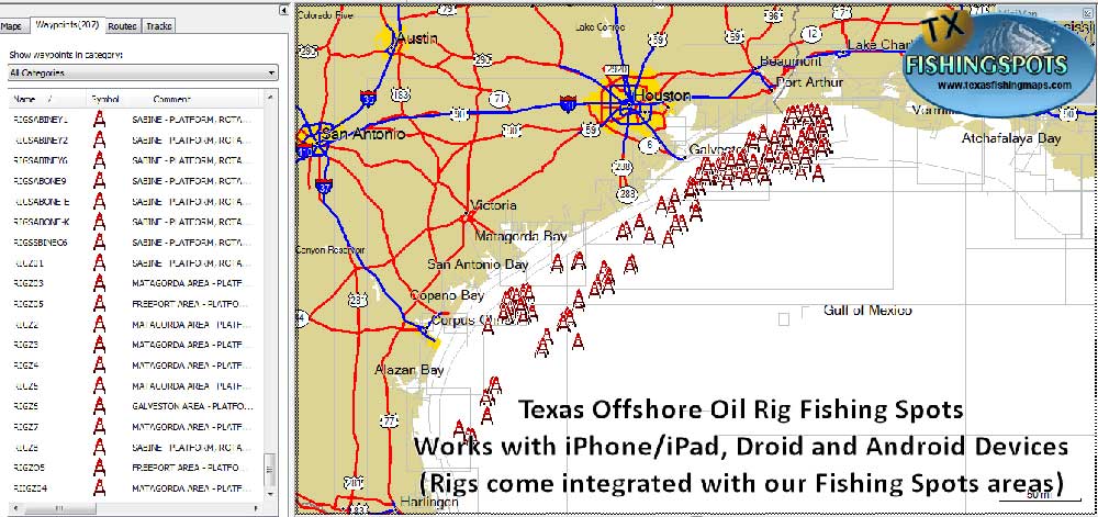
LOOKING FOR ALL THE OLD RIGS? See the Texas Oil Rig fishing spots map with more than 700 rig locations and OLD rig locations for fishing up to 270 Miles Offshore. The below image shows the old rigs GPS Coordinates imported to a GPS using our preloaded SD card available at checkout. (GPS views will vary greatly depending on brand and installed mapping/charts)
We provide the proper waypoint file for your GPS upon purchase of any Texas Fishing spots. We offer the proper waypoint formats for Garmin, Simrad, Raymarine (hybrid/touch model Raymarine only), Humminbird, Lowrance and Furuno TZ Touch models that accept an SD or Micro SD Card. Info about GPS Uploads Many productive Rigs are included with offshore areas we offer – Many current oil rig locations are included with your purchase of any offshore Texas Offshore Fishing Spots location(s). The Oil Rig Spots shown below are directly uploaded to a GPS. Views may vary depending on your GPS base mapping and the fishing spots area you purchase.You must purchase the fishing spots for an area to get the oil rig locations. Purchase any of the offshore fishing spots maps using the links below. All the areas linked below will include current oil rig locations out to 50 NM offshore. Port Arthur to Galveston Texas Offshore Fishing Map – Freeport to Matagorda Texas Offshore Fishing Map – South Padre Island Texas Offshore Fishing Map – Matagorda to Corpus Christi Texas Offshore Fishing Map – OLD Oil Rig GPS Spots Map (over 700 Rig locations, old, abandoned rigs and several current rigs)

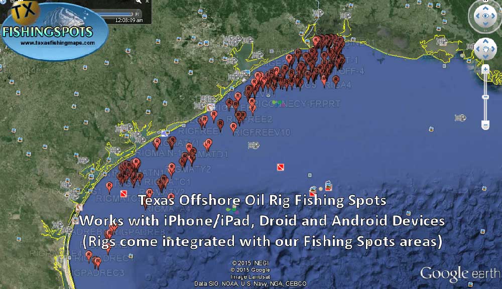
This image and the above simply show the oil rigs we currently offer per area. See a simple Google Earth Texas Oil Rig Spots map and locations shown below. All our files work with mobile devices and all computers using Google Earth and several other GPS apps. NOTE: Oil Rig spots only come with the Fishing spots area you purchase. Sorry, you cannot purchase the rigs only at this time, they are included per area with our fishing spots in each offshore area listed below, so choose an area! Port Arthur to Galveston Texas Offshore Fishing Map – Freeport to Matagorda Texase Offshore Fishing Map – South Padre Island Texas Offshore Fishing Map – Matagorda to Corpus Christi Texas Offshore Fishing Map – OLD Oil Rig GPS Spots Map (over 700 Rig locations, old, abandoned rigs and several current rigs)

Note: When you purchase Texas Offshore fishing spots, all locations will include many oil rig locations (not all rigs are included, but many) out to 50 miles along with hundreds of other proven fishing spots. Again, this will not be all the oil rigs.
However, see our oil rigs master list including the old rigs from 2004!. See the old oil rigs list of over 700 rig locations here.
The rigs we provide within our fishing spots areas are scattered to around 40-50 miles offshore. (Click here to see all Texas Fishing spots Locations) Please use our super fast contact form found here for a speedy response to questions of any kind! We’re here to help our customers 15 hours each day, 7 Days a week. If you send an email using the contact form, rest assured you will be contacted back in short order. This company was built on Customer Service and having the best fishing spots available in the most organized and versatile format available, for all your GPS devices. Thank you for looking.. Fish On! — Dana King G.M. – GPS Fishing Maps Co., A professional Waypoint development Company. (Powered by Local Guides, for Fishermen!)

